Mixed weather to come
Date published: 19 July 2019

Photo: Met Office
Mixed weather to come
Scroll down for Video
As many schools across England and Wales break for the summer holidays there is heavy rain and some heavy, thundery showers in the forecast.
On Friday morning heavy rain, which could impact driving conditions in Wales and south west England, will soon spread north-eastwards reaching southern Scotland later.
Heavy showers, some perhaps thundery, may then follow into parts of Northern Ireland, Wales and northern and central England. Further bouts of wet weather later on Friday will leave parts of southern and southwestern England quite wet during the evening rush hour before some areas in southeast England become quite wet on Friday night.
Saturday will be a brighter day with some sunny spells but also a chance of showers. These showers will be heavy and thundery in places, and could be accompanied by hail, all of which could again adversely affect driving conditions.
Sunday looks better for many with sunny spells and patchy cloud away from western Scotland and Northern Ireland. Here there will be steadily increasing cloud, outbreaks of rain, and winds will strengthen through the day.
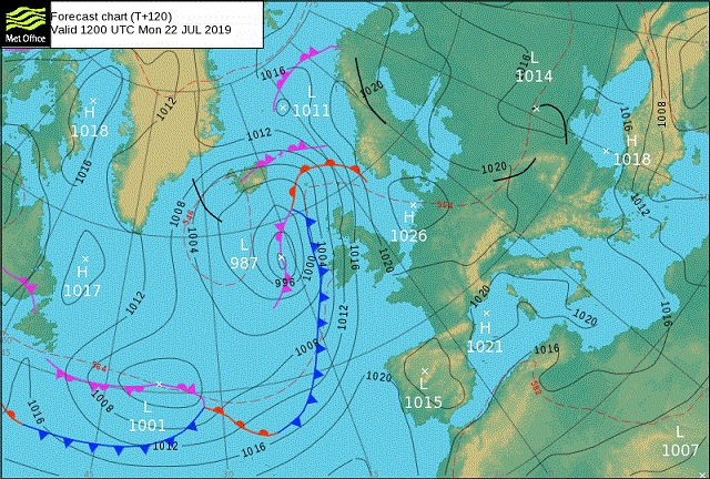
Deputy Chief Meteorologist Dan Harris said: “As we head into next week we are expecting some parts of the country to see some very warm weather, which could reach heatwave thresholds. However, in the cloudier, windier and wetter parts of the north west temperatures will be nearer normal despite high humidity.
There has been some speculation in the media that the warm weather is due to a ‘continental heat dome’. This is not a meteorological term that is recognised professionally and the origin of the term is unclear. As can often happen at this time of year, a high-pressure system will develop over the near continent, bringing warm continental air into the south and east of the UK.
As the school holidays get underway for many the RAC’s Rod Dennis said: “The fine weather is about to take an unwelcome break for some just as thousands of families take to the car to head off on holiday. Drivers are going to have to take particular care and could have not just queues of traffic but also heavy rain and gusty winds to contend with, at least at the start of the weekend.
“It is vital motorists check their vehicles are ready for longer drives – breakdowns are never welcome in any weather, but the being stuck at the side of the road in the wind and rain is surely one of the worst ways of starting a well-earned summer break. Ensuring oil and tyre pressure levels are correct, and that tyres are properly inflated, can go a long way towards avoiding the prospect of a breakdown.”
Published on Thursday 18 July, 2019: The rest of this week sees a change to wetter weather, with Friday and Saturday in particular promising some big downpours. Next week brings potentially big contrasts across the country and the possibility of some higher temperatures in the south. Alex Deakin talks through the scenarios
©Met Office - Weather
Do you have a story for us?
Let us know by emailing news@rochdaleonline.co.uk
All contact will be treated in confidence.
Most Viewed News Stories
- 1Royton haulage firm fined after Rochdale dad went to work and didn’t come home
- 2Six men arrested in Rochdale child exploitation investigation
- 3Rochdale church to host Camerados public living room
- 4Suspended council candidate was ‘politically naive’ for appearing in George Galloway video, leader...
- 530 years of the GEM Appeal, a Rochdale-founded charity that has raised millions and changed the...
To contact the Rochdale Online news desk, email news@rochdaleonline.co.uk or visit our news submission page.
To get the latest news on your desktop or mobile, follow Rochdale Online on Twitter and Facebook.


